CALGARY, Alberta, Aug. 05, 2025 (GLOBE NEWSWIRE) — Bocana Resources Corp. (TSXV: BOCA) (Frankfurt: VC1) (“Bocana” or the “Company“) is pleased to announce that it has entered into a binding letter of intent (the “LOI“) dated July 24, 2025 for the proposed acquisition (the “Transaction“) of 100% of the rights, title and interests in the U.S. Bureau of Land Management (“BLM“) placer mining claims (the “Claims“) owned by LP Associates, LLC of Buffalo MN. (“LPA, LLC” or the “Seller“), an arm’s length limited liability company formed under the laws of the State of Minnesota.
The Transaction
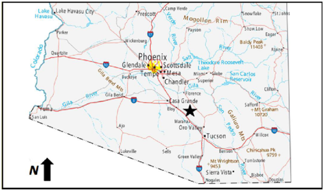
The Claims, which are comprised of seventy-two (72) 20-acre claims, total approximately 1,440 acres in size. The Claims are located in Pinal County, Arizona, approximately 85 miles southeast of Phoenix (Figure #1) and are in two contiguous areas, one containing 1,240 acres and the other block containing 160 acres. Figure # 2 also provides a more detailed location of the placer claims.
Pursuant to the LOI, Bocana will acquire a 100% ownership interest in the Claims through a newly formed subsidiary, Arizore LLC, a limited liability company registered in the state of Nevada. Bocana will acquire the Claims for a total purchase price of US$27,500,000 (the “Purchase Price“). An initial $200,000 deposit has been made to the Seller, which shall be applied as a credit toward the Purchase Price at closing.
“Bocana is very pleased with the proposed acquisition of the LPA, LLC’s Claims. This acquisition is significantly better than several of the other opportunities that the Company has reviewed, and we look forward to developing this asset as quickly as possible for the benefit of our shareholders,” said Tim Turner, Bocana’s Chief Executive Officer.
The transactions contemplated by the LOI are subject to the following conditions:
a) The entering into of a definitive agreement in respect of the Transaction (the “Definitive Agreement“) between LPA, LLC and Bocana. The Definitive Agreement will describe the terms and conditions upon which the Transaction will be completed;
b) the completion of all financing by Bocana to satisfy the Purchase Price;
c) the completion of satisfactory due diligence by Bocana; and
d) regulatory approvals, including but not limited to the TSX Venture Exchange.
The Transaction will be treated as a “Fundamental Acquisition” pursuant to TSX Venture Exchange Policy 5.3. No finder’s fees are to be paid in connection with the Transaction.
Figure # 1- Location Map of Placer Claims
Historical Technical Reports
Technical reports have been prepared for four (4) of the Claims in accordance with National Instrument 43-101 – Standards of Disclosure for Mineral Projects (“NI 43-101“). The results of these technical reports are briefly summarized below.
1. Placer Mining Claim LPA4-04- 20 Acres
The first technical report, entitled Technical Report for the LPA4-04 Placer Gold Claim in the Florence Basin, Pinal County, Arizona, USA, was prepared by A. Roach, Ph.D., R.G., with an effective date of January 25, 2021. Data disclosed in this news release on the LPA4-04 claim was provided from this report.
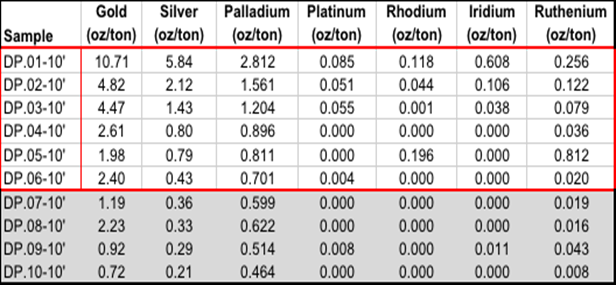
Figure # 3 provides the location of the auger drill holes completed on the LPA4-04 placer claim. Table #1 provides the assay results from the auger drill holes.
Key Findings:
- Average grade estimations of 4.6 oz/ton of gold and 1.9 oz/ton of silver (Table # 1) from 6 drill holes.
- Multi-element assay results.
- Assay results were from auger drilling to 10-foot depths.
- Consistency of high-grade gold assay results in all holes (Table # 1).
Figure # 2 – Location Map of Placer Claims
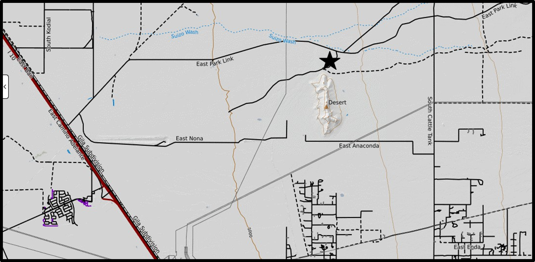
Figure # 3 – Drill Hole Location Map
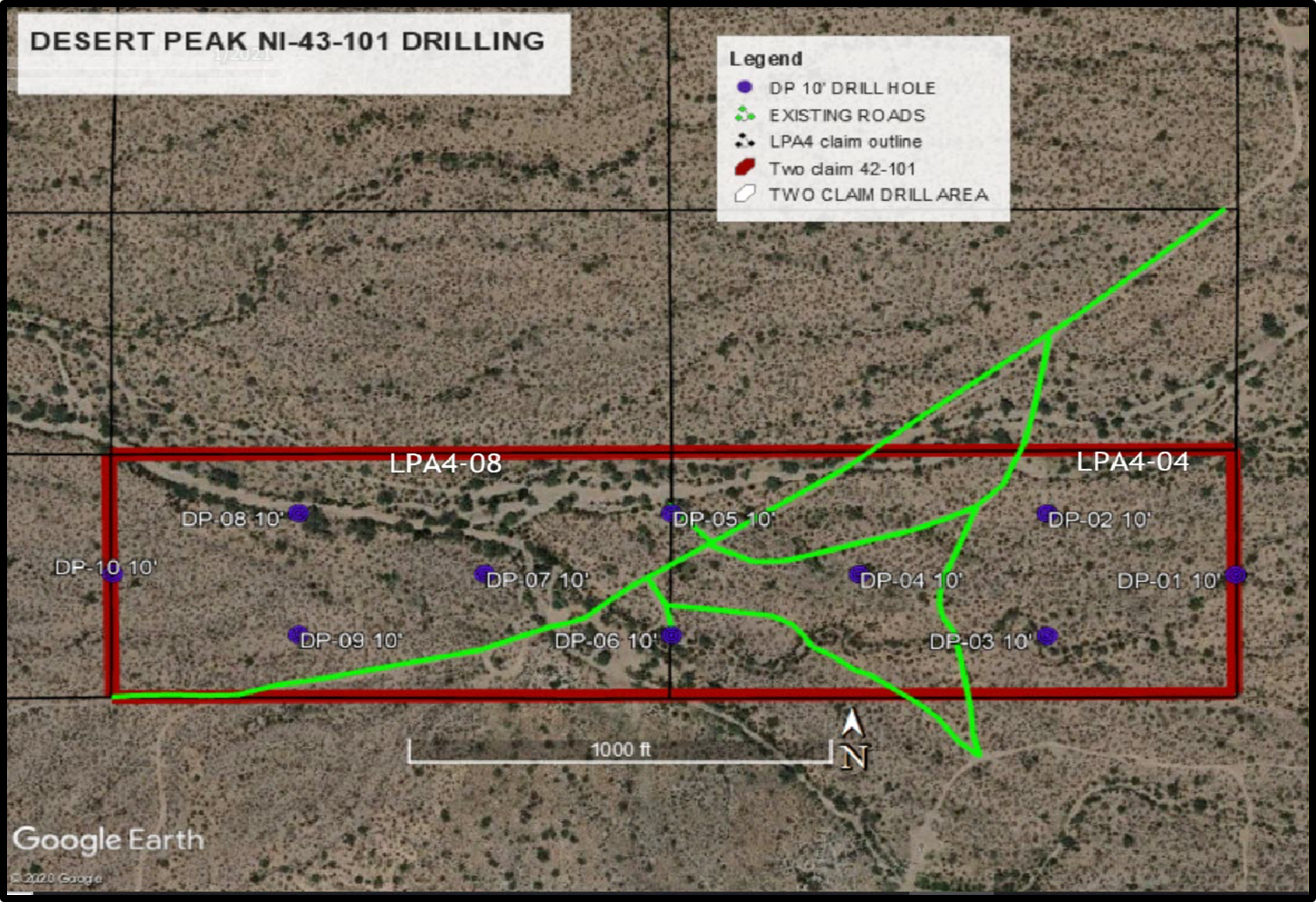
Table # 1 – Holes DP01-06 Located on LPA4-04 Placer Claim
2. Placer Mining Claim LPA4-08- 20 Acres
The second 20-acre technical report, entitled Technical Report for the LPA4-08 Placer Gold Claim in the Florence Basin, Pinal County, Arizona, USA, was prepared by A. Roach, Ph.D., R.G., with an Effective date of January 25, 2021. Drill hole locations posted on Figure #3, DP-07-10, Table # 1 provides the multi-element assay results.
Key Findings:
- Average grade estimates of 1.4 oz/ton (48 g/t) of gold and 0.4 oz/ton (13.7 g/t) of silver were determined from 4 holes.
- Similar consistency in higher grade gold concentrations as in LPA4-04 results.
- Multi-element concentrations lower than adjoining claim LPA4-04 to the east.
3. Placer Mining Claim Dirt-01 – 20 Acres
The third technical report, also on a 20-acre claim, entitled Technical Report for the Dirt-01 Placer Gold Claim in the Florence Basin, Pinal County, Arizona, USA, was prepared by Ronnie G Parker, CPG-#06163, with an Effective date of February 1, 2022. The Dirt-01 Placer Gold Claim is located approximately 1-1/2 miles (0.9 kilometer) west of Highway 79. Highway 79 may be accessed by Highway 77 and Interstate 10, which is located 27 miles (43.2 kilometers) to the south and west of the claim, as shown on Figure #4 below. Figure # 5 provides the drill collar locations on the claim. Table # 2 posts the assay results from the drilling program.
Key Findings:
- Average estimated grades of 0.589 oz/ton (16.7 g/t) of gold and .475 oz/ton (13.5 g/t) of silver from 9 drill holes.
- Demonstrating consistency in higher-grade mineralization.
Figure #4 Dirt-01 Location Map
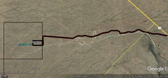
Figure #5 – Drill Collar Location Map – Dirt-01 Placer Claim
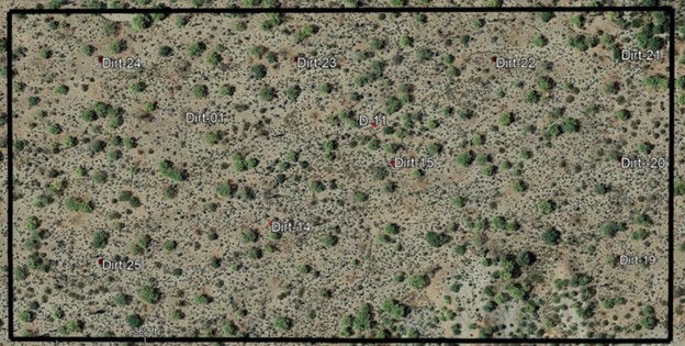
Table 2. – Assay data from the DIRT-01 Placer Gold Claim for the 2020 drill holes.
| Assay Date | Sample # | Gold oz/ton |
Silver oz/ton |
Platinum oz/ton |
Palladium oz/ton |
Rhodium oz/ton |
|
| 11-Mar-20 | Dirt-14 | 0.287 | 0.200 | 0.207 | 0.099 | 0.067 | Fire+ AA |
| 10-Mar-20 | Dirt-15 | 0.380 | 0.291 | 0.166 | 0.102 | 0.031 | Fire+ AA |
| 13-Jul-20 | Dirt-19 | 0.457 | 0.492 | 0.044 | 0.034 | 0.038 | Fire+ AA |
| 13-Jul-20 | Dirt-20 | 0.474 | 0.510 | 0.068 | 0.040 | 0.044 | Fire+ AA |
| 15-Aug-20 | Dirt-21 | 0.379 | 0.409 | 0.025 | 0.031 | 0.038 | Fire+ AA |
| 15-Aug-20 | Dirt-22 | 0.275 | 1.330 | 0.019 | 0.031 | 0.030 | Fire+ AA |
| 15-Aug-20 | Dirt-23 | 1.219 | 0.398 | 0.028 | 0.019 | 0.033 | Fire+ AA |
| 15-Aug-20 | Dirt-24 | 0.945 | 0.601 | 0.029 | 0.028 | 0.026 | Fire+ AA |
| 15-Aug-20 | Dirt-25 | 0.885 | 0.047 | 0.031 | 0.027 | 0.031 | Fire+ AA |
4. Placer Mining Claim Dirt-02 – 20 Acres
The fourth 20-acre technical report, entitled NI-43-101 Technical Report for the Dirt-02 Placer Gold Claim in the Florence Basin, Pinal County, Arizona, USA, was prepared by Ronnie G Parker, CPG-#06163, with an Effective date of February 1, 2022 and a Technical Update as of August 8, 2022. The Dirt-02 Placer Gold Claim is located approximately 2-1/2 miles (0.9 kilometer) west of Highway 79. Highway 79 may be accessed by Highway 77 and Interstate 10, which is located 27 miles (43.2 kilometers) to the south and west of the claim. Access to the claim is via a small dirt road off Highway 79 at mile marker 10. See Figure #6. Figure #7 provides the Dirt-02 drill collar locations.
Figure #6 – Dirt-02 Location and Access.
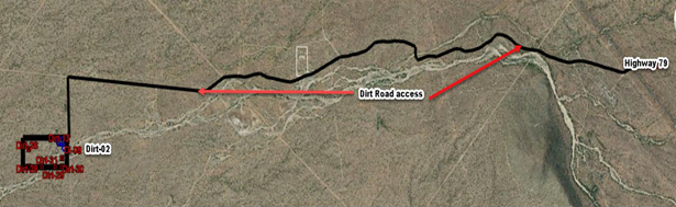
Figure #7 Drill Collar Locations
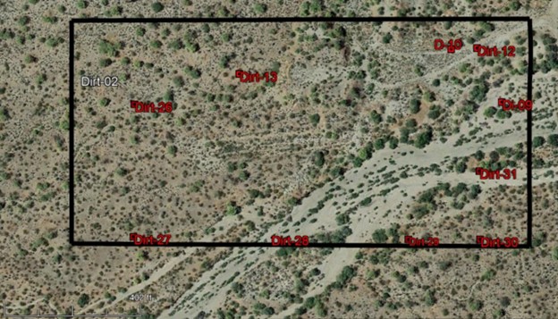
Table #3 Assay information for the 2020 drill holes from the DIRT-02 Placer Gold Claim.
All data listed below is shown in ounces per ton.
|
Assay Date |
Sample # |
Gold |
Silver |
Platinum |
Palladium |
Rhodium |
| 15-Aug-20 | Dirt-26 | 0.374 | 0.499 | 0.028 | 0.021 | 0.035 |
| 15-Aug-20 | Dirt-27 | 0.608 | 0.800 | 0.033 | 0.025 | 0.042 |
| 15-Aug-20 | Dirt-28 | 0.376 | 0.505 | 0.037 | 0.024 | 0.040 |
| 15-Aug-20 | Dirt-29 | 0.316 | 0.755 | 0.032 | 0.026 | 0.030 |
| 15-Aug-20 | Dirt-30 | 1.005 | 0.743 | 0.040 | 0.036 | 0.027 |
| 15-Aug-20 | Dirt-31 | 0.558 | 0.963 | 0.042 | 0.020 | 0.057 |
| 22-Mar-18 | Dirt-09 | 0.189 | 0.202 | – | – | – |
| 23-Mar-18 | Dirt-10 | 0.148 | 0.200 | – | – | – |
| 11-Mar-20 | Dirt-12 | 0.46 | 0.40 | 0.165 | 0.1 | 0.041 |
| 11-Mar-20 | Dirt-13 | 0.49 | 0.4 | 0.183 | 0.086 | 0.033 |
Key Findings:
- Average grades from 10 drill holes – 0.452 oz/ton (12.81 g/t) of gold and 0.546 oz/ton (15.48 g/t) of silver.
- All drill holes assayed high gold concentrations.
- Continuation of multi-element mineralization.
Comments on Sampling
Drilling was conducted using a two-man auger. Sufficient auger flights were required to reach depths up to 11 feet (3.05 meters). Sample material was collected in a specially designed metal container that surrounded the auger. Samples were transferred to a clean plastic bucket for transport to the splitting location.
Sample splitting was conducted onsite with a small riffle splitter. The site geologist performed the sample splitting. One split of material was packaged in a plastic bag for sample analysis. The remaining portion of the split was returned to the plastic bucket for storage at a secure locality off-site. The splitter was cleaned between samples. All historical assay results are documented in the four NI-43-101 reports provided to the Company; however, assay certificates indicating the methods used, weight of samples, details on the assay procedures were not in the reports and have not been provided to the Company.
Conclusions/Recommendations
Historical assay results indicate potentially economic concentrations of gold with associated silver, platinum, palladium, and rhodium on all four claims mentioned. Bocana will require due diligence studies, including additional drilling, sample assays, and metallurgical studies to confirm the results from each of these four reports.
It is recommended that, in future drilling programs on all of the claims that notes on detailed logging of the sample material be undertaken, in particular the presence/ absence of apparent gravel layers during the drilling, along with approximate depth. The removal of gravel from samples, either because it is not carried by the auger or is at the splitting stage, has the potential to lead to higher or lower assay values. Therefore, one or more bulk samples should be taken in order to assess whether grades are significantly different than those obtained by drilling.
Qualified Person
Mr. Lorne Warner, P.Geo., the Company’s consulting geologist, is an independent, “Qualified Person” as defined by NI 43-101. Mr. Warner has approved the scientific and technical information included in this news release for dissemination.
The LOI was negotiated at arm’s length. The Transaction does not represent a change of business. There will be no change of directors or officers of the Company required by the Transaction.
The TSX Venture Exchange has in no way passed upon the merits of the Transaction and has neither approved nor disapproved the contents of this press release.
About Bocana Resources Corp.
Bocana is a mineral exploration company focused on the acquisition, exploration, and development of mineral properties in North and South America. Bocana, through its wholly owned subsidiary, Huiracocha International Service SRL, holds a 100% working interest in the mineral properties known as the Escala area concessions located in the Department of Potosi, Sud Lipez Province, Bolivia, as awarded by Comibol.
Contact Information
For more information on Bocana, visit: https://bocanaresources.com.
For more information or interview requests, please contact:
Timothy J. Turner – Chief Executive Officer
info@bocanaresources.com
(713) 858-3329
Forward-Looking Information
This news release contains “forward-looking information” within the meaning of applicable securities laws. Forward-looking information can be identified by words such as: “intend”, “believe”, “estimate”, “expect”, “may”, “will”, “approximately”, “planning”, “projected”, “anticipate”, and similar references to future periods. Forward-looking information is subject to known and unknown risks, uncertainties and other factors that may cause the actual results, level of activity, performance or achievements of Bocana, as the case may be, to be materially different from those expressed or implied by such forward-looking information, including but without limitation, statements pertaining to the Transaction including Bocana’s ability to obtain financing and the necessary approvals, including regulatory approvals for the Transaction, the negotiation and execution of the Definitive Agreement, the estimates of potential quantity, grade, and metal and mineral content at the Claims, Bocana’s assessment of the reliability and relevance of the historical drill results, and the ability of Bocana to operate the exploration and development programs for the Claims. All statements included herein involve various risks and uncertainties because they relate to future events and circumstances beyond Bocana’s control.
Forward-looking statements are inherently uncertain, and the actual performance may be affected by several material factors, assumptions and expectations, many of which are beyond the control of the parties, including expectations and assumptions concerning (i) the Seller; (ii) the Transaction; (ii) the ability of the Parties to negotiate and enter into the Definitive Agreement on satisfactory terms as proposed, (iii) the timely receipt of all required regulatory approvals (as applicable), including the approval of the TSXV, (iv) if the Definitive Agreement is entered into, the satisfaction of other closing conditions in accordance with the terms of the Definitive Agreement, and (v) the ability of the Parties (as applicable) to complete the Financing and/or the Transaction on the terms outlined in this news release (or at all). Although Bocana has attempted to identify important factors that could cause actual results to differ materially from those contained in forward-looking information, there may be other factors that cause results not to be as anticipated, estimated, or intended. Readers are cautioned not to place undue reliance on forward-looking information. The forward-looking statements contained in this news release are made as of the date hereof, and the Company undertakes no obligation to update publicly or revise any forward-looking statements or information, except as required by law. This news release shall not constitute an offer to sell or the solicitation of an offer to buy any securities in any jurisdiction.
Neither the TSX Venture Exchange nor its Regulation Services Provider (as that term is defined in the policies of the TSX Venture Exchange) accepts responsibility for the adequacy or accuracy of this news release.
Images accompanying this announcement are available at
https://www.globenewswire.com/NewsRoom/AttachmentNg/f1961def-47e8-4cdb-a475-28cc521966a6
https://www.globenewswire.com/NewsRoom/AttachmentNg/8e47a243-803b-4b79-8761-cd72eb04c376
https://www.globenewswire.com/NewsRoom/AttachmentNg/7dcf670a-22df-4946-b7ae-e92087d9aebf
https://www.globenewswire.com/NewsRoom/AttachmentNg/aa10b141-9084-4454-89b7-3e7a3ac42333
https://www.globenewswire.com/NewsRoom/AttachmentNg/83c9f188-1c36-4e9b-887e-f82e0a78cf27
https://www.globenewswire.com/NewsRoom/AttachmentNg/27ffe6c4-dcd3-4ac6-9f20-08d868830d1b
https://www.globenewswire.com/NewsRoom/AttachmentNg/bfa958ea-6922-4b89-a17d-1927633fb98b
https://www.globenewswire.com/NewsRoom/AttachmentNg/9b29f0f1-cef9-40f6-9c02-34d7bac0c411

